Inherent soil properties are a soil’s natural features; they fall outside the control of any land manager’s actions. Inherent properties have a great impact on the suitability of a soil to produce certain crops, as well as its overall productivity. In Ontario, inherent soil properties are a byproduct of glacial activity and retreat. Understanding inherent properties and how they vary between and within fields lays a foundation for improved soil management. This factsheet covers the topics of soil formation, soil variability, soil texture, soil colour, and natural drainage. Read on to learn more.
Soil Formation
Five soil-forming factors contribute to the development of different soils across the landscape: climate, organisms, topography, parent materials, and time.
Climate
- Precipitation dissolves minerals and salts, which move downward with water through the soil profile.
- Average temperatures influence which plants and other organisms live in the soil and the speed of soil formation.
Organisms
- Macro-, meso- and microorganisms living in soil decompose plant and animal tissues and wastes, which contribute to stable soil organic matter.
- Organisms and the soil organic matter they help create affect the size and shape of clumps of soil particles, which contributes to overall soil structure.
Topography
- The landscape position (or relief) of a soil affects its characteristics.
- Soils on slopes often experience more erosion, while soils in valleys are typically much deeper due to greater water availability and deposition of eroded soil from above.
- A soil’s position in the landscape influences its natural drainage.
Parent Materials
- Soils develop from parent materials including minerals, stones, and rocks.
- Some soils form directly over bedrock, while others develop from the materials transported and deposited by glaciers, gravity, wind, rivers, lakes, or oceans.
- Parent material gives a soil its properties such as texture and mineral composition.
Time
- Younger soils are typically shallower and older soils have more well-defined soil horizons.
- Parent material impacts the time required for soil to form. For example, soil forms more quickly in wind-blown sediments than from bedrock, as bedrock requires weathering before plants can grow.
The properties of Ontario’s soils are closely related to landforms that were created by glacial ice, meltwaters, glacial lakes, and wind. Glaciers moved across all of Ontario, grinding rock into fine particles, and mixing and moving existing soil. As the glaciers retreated, they dropped soil materials from within the ice itself. The meltwater deposited gravel and sands as mixed layers. Flat beds of sand, silt and clay were deposited by lakes that formed from the ponding of melt waters. The soils were further distributed as strong winds moved across these landscapes. The soils of today were developed on these deposits.
Examples of landforms in Ontario include:
- shallow over bedrock (e.g., Farmington soil series)
- muck or peat (e.g., Holland Marsh)
- till plain (much of southern Ontario’s field cropland – see Figure 1)
- end moraine (e.g., portions of Grey and Peterborough Counties)
- sand plain (e.g., sand plains of Haldimand-Norfolk)
- and clay plain (e.g., much of Essex County)
Additional information and illustrations of the landforms can be found in the OMAFA publication Best Management Practices: Soil Management.
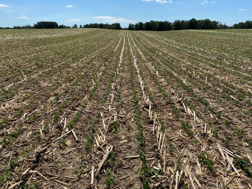
Figure 1. A gently rolling till plain soil (Harriston loam) in Huron County.
Soil Variability
The soils of Ontario vary greatly. Some are very shallow to bedrock, while others have more than 100 m (328 ft) of overburden. Depth of topsoil varies depending on the conditions for soil formation, as well as topography and soil degradation processes over time. The Ontario Topsoil Sampling Project measured topsoil depth at over 500 sites and found upper slope positions to be thinner (22.8 cm (9.0 in.)) than lower positions (25.8 cm (10.2 in.)) (Saurette et al., 2024). Physical barriers, such as a change in soil texture or high water tables, can restrict plant rooting depths. The deeper and more well-drained a soil, the more productive crop growth will be.
The soil on a farm may be uniform or may be made up of many different soil map units. It is useful to know what the soil types are for a particular field. One approach is to look up the field on a county soil map. Many soil maps come with a report that provides more information about the soil. Soil type can also be determined – along with other attributes such as drainage and hydrologic soil group – online using the AgMaps website at ontario.ca/agmaps. Soil maps are available through Service Ontario.
Farmers have long been aware of soil variability and attempted to improve less productive areas. Differences in crop growth are the simplest clue to soil differences within field. Commercial in-field mapping options exist, which use yield monitor data in combination with information such as topographic maps and electrical conductivity to develop management zones (distinct areas of the field that are sampled and managed differently). Alternatively, a small amount of digging with a shovel or probing can reveal major differences in soil properties across short distances within a field (Figure 2).
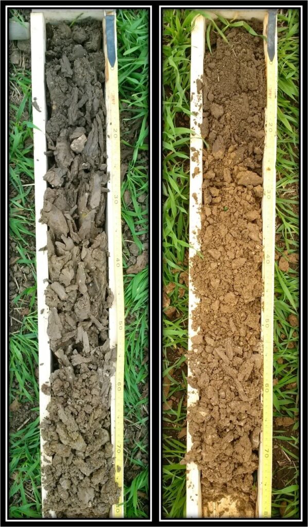
Figure 2. Dark-coloured, more poorly drained (left) vs. lighter, well-drained soil (right), collected from within a hundred feet of one another on a loam soil in Wellington County.
Soil Texture
Soil texture is the proportion of sand, silt, and clay mineral particles within the soil. Depending on the mixture, soil texture is classified as a particular type, e.g. silt loam (SiL) or sandy loam (SL) (Figure 3). Soils that contain predominately sand are considered coarse or light texture soils (larger particle size), those with mostly clay are considered fine or heavy texture soils (small particle size), and those with a mixture are considered medium-textured (loam). Soil texture not only varies across the landscape but can also vary with depth within the soil profile.
Soil texture impacts many soil functions, including infiltration and plant available water, nutrient-supplying capacity, and habitat for soil organisms. Sandy soils typically allow water to easily infiltrate, but have limited capacity for holding water, whereas clay soils behave inversely, with slower infiltration and a higher water holding capacity. Soil management practices are modified to account for these inherent differences amongst fields and sometimes within the same field.
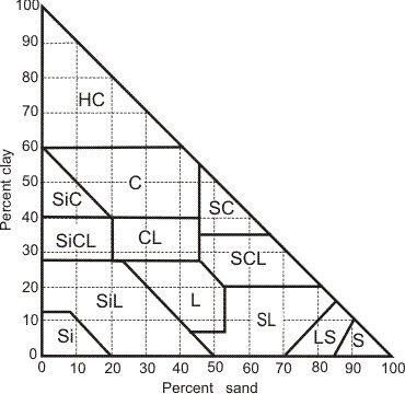
Figure 3. Soil textural classes triangle for Canada. Source: Soil Classification Working Group, 1998.
Soil Colour
Soil colour can be a useful cue to better understand soil properties. Colour at the soil surface across a field is a visual indicator of soil organic matter levels. Lighter-coloured soil on a ridge or knoll, for example, can reveal the loss of topsoil due to tillage and water erosion (see Figure 4). Tillage that mixes lower organic matter subsoil can also cause the soil surface to appear lighter.
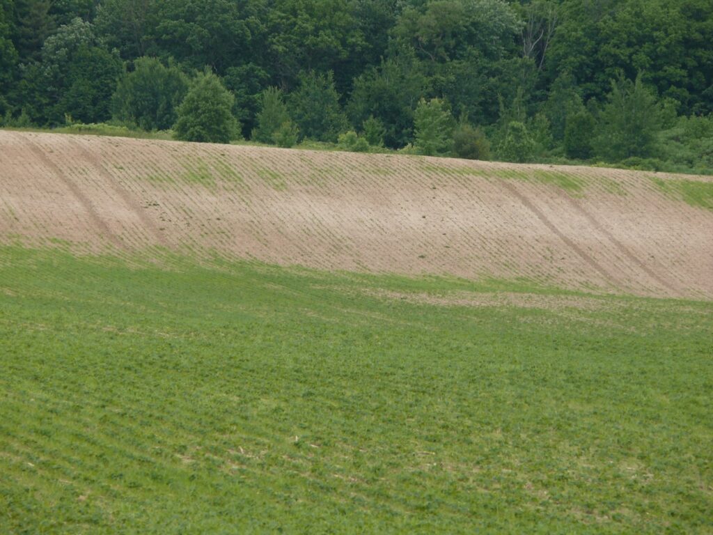
Figure 4. Eroded ridge showing lighter coloured soil and poor crop growth.
Colour is also an indicator that can help to identify soil horizons and give insight into their properties at depth. For example, drainage characteristics of a soil can be determined by looking at soil colour. As the water table rises it creates an anaerobic environment in which iron in soil reduces to a grey colour. When the water table lowers, oxygen returns, and the iron oxidizes into orange-coloured mottles (a mix of grey & red; Figure 5). Grey soil colour indicates poorer natural drainage while orange mottles denote a fluctuating water table and imperfect drainage.
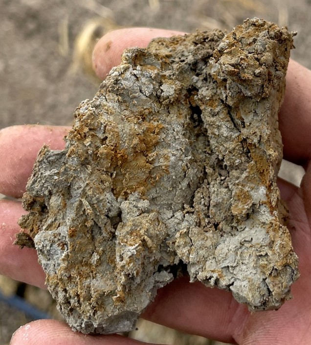
Figure 5. Mottles indicate a fluctuating water table and imperfect drainage.
Natural Drainage
How well a soil drains affects the timeliness of field operations, water erosion, root growth, soil compaction risk, and the amount of air in a soil. Soil drainage classifications range from very rapidly drained to very poorly drained and are affected by soil texture, depth to water table, and the frequency and duration of saturation. In a poorly-drained soil, water is removed slowly and the water table is near the surface frequently. An impermeable underlying area (e.g., clay layer underlying sandy topsoil) may exist. In well-drained soils, water leaves the soil readily but not rapidly and available water storage is intermediate. Typically, poorly-drained soils are found in low lying areas and hill bottoms while well-drained soils are in higher slope positions. Subsurface tile drainage removes excess soil water and improves soil aeration; it provides longer windows in spring and fall for field work and improves crop rooting and growth.
Resources
Capability for Agriculture
https://www.ontario.ca/page/soil-capability-agriculture-ontario
How to Use Ag Maps
https://www.ontario.ca/page/how-use-agmaps
Soils of Ontario
https://openpress.usask.ca/soilscience/chapter/soils-of-ontario
References
Ontario Ministry of Agriculture, Food and Rural Affairs. 1997. Best Management Practices: Soil Management.https://bmpbooks.com/publications/soil-management/.
Saurette, D., Burns, T., Blackford, C., Warren, J., Arntz-Gray, J., Kelly, R., Jefferies, D., Munroe, J., Nemeth, D. The Ontario Topsoil Sampling Project (OTSP): Soil Health Baseline Study. 2024. Ontario Ministry of Agriculture, Food and Agribusiness. Retrieved on November 12, 2024 from https://www.ontario.ca/page/ontario-topsoil-sampling-project-2024.
Saurette, D., Warren, J., Heck. R. 2022. A proposed framework for assigning soil drainage classes to non-redoximorphic soils in the Canadian System of Soil Classification. Canadian Journal of Soil Science. 102(4): 867-878. https://doi.org/10.1139/cjss-2022-0024.
Soil Classification Working Group. 1998. The Canadian System of Soil Classification, 3rd ed. Agriculture and Agri-Food Canada Publication 1646, 187 pp. Retrieved on November 12, 2024 from https://sis.agr.gc.ca/cansis/taxa/cssc3/chpt17.html.
Soil Drainage Class. 2013. National Soil Database. Retrieved November 12, 2024 from https://sis.agr.gc.ca/cansis/nsdb/soil/v2/snt/drainage.html.